
Vehicle Safety in the Mendocino
Mendocino National Forest
March 25th, 2025

The route markers shown below identify the three types of transportation systems on the Mendocino National Forest. These markers are typically posted at the entrance of roads and motor vehicle trails and at trailheads. To ensure you are operating on a route legally designated for your vehicle type, you will need to refer to the Mendocino National Forest Motor Vehicle Use Map (MVUM).

The National Forest Primary Route and Horizontal Route Markers are used to identify roads recommended and maintained for highway-legal vehicles. OHV, ATV, or UTV travel is prohibited on these roads unless otherwise designated. If the road is not designated for mixed-use, only vehicles that are highway-legal may travel on these roads. Please note that forest road conditions can change quickly, especially given post-fire hazards and storm damage. Downed trees, slides, rockfall, snow or ice fields can make roads impassable at any time. Forest roads are not maintained in winter. A high clearance 4wd vehicle with good tires is recommended when traveling in the forest.

The Vertical Route Marker is placed on roughly graded roads that are recommended for high-clearance vehicles, 4WD and pick-ups. The “mixed-use” of street legal and non-street legal motor vehicles (OHV) is allowed on these roads unless otherwise designated. See Mendocino National Forest MVUM for legal designations. When traveling these types of roads, you can expect to encounter a variety of street legal passenger vehicles and four-wheel drives, as well as non-street legal vehicles like dirt bikes, ATVs, dune buggies, and other types of specialized or modified vehicles. When traveling these roads, please keep your speed down to 15 mph, stay to the right and observe all rules of the road.
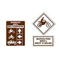
Sharing Routes (Mixed Use)
The National Forests allow multiple uses. As you travel around, you may encounter visitors pursuing various activities, with different interests, all using forest roads and trails at the same time. Courtesy for other uses is essential for everyone to have a safe and enjoyable experience. Please extend the same courtesy and consideration to those around you as you expect from them. If you choose to travel these roughly graded roads, be prepared to encounter rocks, boulders, road washouts, downed trees and brush encroaching on the roadway.
Know Before You Go
Stay On Open Forest Roads
- Travel only on vehicle designated routes. Obtain a Motor Vehicle Use Map for specific information.
- Comply with signs and barriers and leave gates as you found them.
- Wilderness areas are off-limits to all motorized vehicles.
Protect The Environment
- Minimize erosion by staying on trails.
- Teach new riders trail etiquette—lead by example.
Follow Vehicle Regulations
- All vehicles must be registered and licensed.
- Obey all traffic signs. State traffic laws apply to all national forest roads; violations are reported to the state department of motor vehicles.
Free Maps are Available
Pick up a free map of the National Forest System roads and designated off-highway travel routes at your local office.
Or scan this QR code to access the map on your phone:

Remember: You are responsible for your own safety and for the safety of those around you.